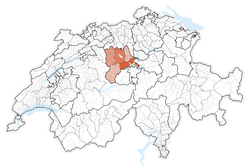
Canton of Lucerne
| Kanton Luzern | |||
|
|||
 |
|||
| Coordinates | |||
| Capital | Lucerne | ||
| Population | 372,964 (12/2009)[1] | ||
| - Density | 250 /km² (647 /sq mi) | ||
| Area | 1,493 km² (576 sq mi) | ||
| Highest point | 2,350 m (7,710 ft) - Brienzer Rothorn | ||
| Lowest point | 406 m (1,332 ft) - Reuss plain at Honauer Schachen | ||
| Joined | 1332 | ||
| Abbreviation | LU | ||
| Languages | German | ||
| Executive | Regierungsrat (5) | ||
| Legislative | Grosser Rat (120) | ||
| Municipalities | 87 municipalities | ||
| Districts | 5 Ämter | ||
| Website | LU.ch | ||
| View map of Lucerne | |||
|---|---|---|---|


Lucerne (German: Luzern) is a canton of Switzerland. It is located in the centre of Switzerland. The population of the canton (as of 31 December 2009) is 372,964.[1] As of 2007[update], the population included 57,268 foreigners, or about 15.8% of the total population.[2] The cantonal capital is Lucerne.
Contents |
History
The canton of Lucerne comprises territories acquired by its capital Lucerne, either by treaty, armed occupation or purchase. The first town acquired was Weggis (in 1380), Rothenburg, Kriens, Horw, Sempach and Hochdorf (all in 1394), Wolhusen and Entlebuch (1405), the so-called "Habsburger region" to the northeast of the town of Lucerne (1406), Willisau (1407), Sursee and Beromünster (1415), Malters (1477) and Littau (1481), while in 1803, in exchange for Hitzkirch, Merenschwand (held since 1397) was given up.[3]
Lucerne grew up around a Benedictine monastery, founded about 750 on the right bank of the Reuss by Murbach Abbey in Alsace, of which it long remained a "cell". It is first mentioned in a charter of 840 under the name of Luciaria, which is probably derived from the patron saint of the monastery, St Leodegar. The name Lucerrun is first mentioned in 1252. At some point, a small village grew up around the monastery. The first signs of a municipal constitution appear in 1252.
With the growing power of the Habsburgs in the area weakened the ties that bound Lucerne to Murbach. In 1291 the Habsburgs finally purchased Lucerne from Murbach. The purchase of Lucerne by the Habsburgs drove the three forest cantons (Uri, Schwyz and Unterwalden) to form an Eternal Alliance, an act that is considered to be the foundation of Switzerland. In 1332 Lucerne became the fourth member of the Eidgenossen or Swiss Confederation, and the first town to join the rural forest cantons.
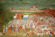

The Battle of Sempach (1386) near Sempach (which while allied wouldn't become part of the canton for 8 more years) drove the Habsburgs out of the region and strengthened the Confederation. That victory led also to the gradual acquisition of territory ruled by and from the town.
Amstalden, a wealthy innkeeper Schüpfheim in the Entlebuch valley of the canton of Lucerne, was the leader of a planned rebellion of the valley against the city of Lucerne. In a plot to limit the power of the city, officials from the neighbouring canton of Obwalden had promised their support. The conspiracy was detected before they could stage the planned coup. On August 24, 1478, Amstalden was arrested, tortured and interrogated, and finally beheaded in November 1478.
The incident furthered the distrust amongst rural and urban cantons in the Old Swiss Confederacy and was one of the reasons for the conclusion of the Stanser Verkommnis in 1481, an important coalition treaty of the cantons of the Old Swiss Confederacy
During the Reformation Lucerne remained Roman Catholic, of which ever since it has been the great stronghold in Switzerland. The papal nuncio resided here from 1601 to 1873. In the 16th century, during the early modern age, the town government fell into the hands of an aristocratic oligarchy, whose power, though shaken by the Swiss peasant war of 1653 in the Entlebuch, lasted till 1798. Under the French supported, Helvetic republic (1798–1803) Lucerne was the seat of the central government. When the republic collapsed, under the Act of Mediation (1803–14) it was one of the six "Directorial" cantons and during the Restoration (from 1815 to 1848) it was one of the three ruling cantons.
The patrician government was swept away by the cantonal constitution of 1831. But in 1841 the Conservatives regained power, called in the Jesuits (1844) and so brought about the Sonderbund War (1847) in which they were defeated, the decisive battle taking place at Gisikon, not far from Lucerne.[4]
Geography
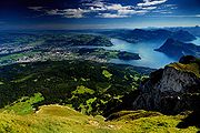
The canton of Lucerne is located in the centre of Switzerland. It is drained by the Reuss river and the river Kleine Emme. The lands of the canton lie on the northern foothills of the Swiss Alps (Urner Alps). The highest elevation of the canton of Lucerne is at the Brienzer Rothorn at 2,350 m (7,710 ft). The area of the canton is 1,493 km2 (576.5 sq mi).
Political subdivisions
Districts
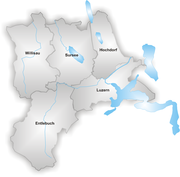
The Canton is divided into 5 districts termed Ämter:
- Amt Luzern with capital Luzern
- Amt Hochdorf with capital Hochdorf
- Amt Sursee with capital Sursee
- Amt Willisau with capital Willisau
- Amt Entlebuch with capital Schüpfheim
Municipalities
There are 88 municipalities in the canton (As of 2009[update]).[5]
Demographics
The population is mainly German (as of 2000[update], 89%[6] speaking and the vast majority is Roman Catholic (71% as of 2000[update], with a 12% Protestant minority.[7])
| Demographic history of the Canton of Luzern 1850–2000 | |||||||||
|---|---|---|---|---|---|---|---|---|---|
| Year | 1850 | 1880 | 1900 | 1950 | 1970 | 2000 | |||
| Population | 132,843 | 134,708 | 146,519 | 223,249 | 289,641 | 350,504 | |||
| Percent of Total Swiss Population | 5.6% | 4.8% | 4.4% | 4.7% | 4.6% | 4.8% | |||
| Language | |||||||||
| German | 134,155 | 143,337 | 216,647 | 263,310 | 311,543 | ||||
| Italian | 294 | 2,204 | 3,587 | 15,635 | 6,801 | ||||
| French | 302 | 747 | 2,150 | 2,015 | 2,053 | ||||
| Romansh | 5 | 64 | 338 | 525 | 388 | ||||
| Other | 50 | 167 | 527 | 8,156 | 29,719 | ||||
| Religion | |||||||||
| Catholic[nb 1] | 131,280 | 129,172 | 134,020 | 189,917 | 246,888 | 248,545 | |||
| Protestant | 1,563 | 5,419 | 12,085 | 30,396 | 38,639 | 42,926 | |||
| Christian Catholic | 1,129 | 741 | 471 | ||||||
| Other | 215 | 414 | 1,807 | 3,373 | 58,562 | ||||
| Other, Jewish | 152 | 319 | 497 | 563 | 399 | ||||
| Other, Islam | 372 | 13,227 | |||||||
| Other, None[nb 2] | 1,672 | 20,681 | |||||||
| Nationality | |||||||||
| Swiss | 132,252 | 132,583 | 140,176 | 216,600 | 259,498 | 294,709 | |||
| Foreign | 591 | 2,223 | 6,343 | 6,649 | 30,143 | 55,795 | |||
| Source: Historical Dictionary of Switzerland[8] | |||||||||
| Notes |
|||||||||
Economy
Much of the land in the canton is used for agriculture. 817.7 km2 (315.7 sq mi), about 55% of the total land area, is used for agriculture. An additional 449.0 km2 (173.4 sq mi) (about 30%) of the canton is wooded. The remainder of the canton is either developed, 125.3 km2 (48.4 sq mi) (8.4%), or unproductive (lakes, rivers or mountains), 101.5 km2 (39.2 sq mi) (6.8%).[9] Agriculture is the most significant source of income, but industry is also developed. The most important agricultural products are crops, fruit and cattle breeding. Industry concentrates on textiles, machinery, paper, wood, tobacco and metallurgical goods.
Tourism is of great importance. The canton of Lucerne is a gateway to holiday resorts in the nearby Alps, and much of the transit traffic between Germany and Italy crosses the region.
Education
Institutions of higher education include the Lucerne University of Applied Sciences which also has campuses in Lucerne and Horw.
External links
- Official Site (German)
- Public Records Office / State Archive (German)
- Official Statistics
- Geoportal (German) GIS
- Canton of Lucerne in German, French and Italian in the online Historical Dictionary of Switzerland.
References
- ↑ 1.0 1.1 Swiss Federal Statistical Office, MS Excel document – Bilanz der ständigen Wohnbevölkerung nach Kantonen, Bezirken und Gemeinden (German) accessed 25 August 2010
- ↑ Federal Department of Statistics (2008). "Ständige Wohnbevölkerung nach Staatsangehörigkeit, Geschlecht und Kantonen" (Microsoft Excel). http://www.bfs.admin.ch/bfs/portal/de/index/themen/01/02/blank/key/raeumliche_verteilung/kantone__gemeinden.html. Retrieved November 5, 2008.
- ↑ "Lucerne (Canton)". Encyclopædia Britannica. 17. 1911. pp. 97. http://books.google.com/books?id=N1YEAAAAYAAJ&pg=PA97#PPA97,M1. Retrieved 2009-04-18.
- ↑ "Lucerne (City)". Encyclopædia Britannica. 17. 1911. pp. 97. http://books.google.com/books?id=N1YEAAAAYAAJ&pg=PA97#PPA97,M1. Retrieved 2009-04-18.
- ↑ "Liste officielle des communes de la Suisse - 01.01.2008". http://www.bfs.admin.ch/bfs/portal/fr/index/infothek/nomenklaturen/blank/blank/gem_liste/03.Document.90142.xls. Retrieved 15 décembre 2008.
- ↑ Federal Department of Statistics (2004). "Wohnbevölkerung nach Sprachen" (Interactive Map). http://www.bfs.admin.ch/bfs/portal/de/index/themen/01/05/blank/key/sprachen.html. Retrieved 2009-01-15.
- ↑ Federal Department of Statistics (2004). "Wohnbevölkerung nach Religion" (Interactive Map). http://www.bfs.admin.ch/bfs/portal/de/index/themen/01/05/blank/key/religionen.html. Retrieved 2009-01-15.
- ↑ Lucerne (Canton) in German, French and Italian in the online Historical Dictionary of Switzerland.
- ↑ Federal Department of Statistics (2008). "Arealstatistik – Kantonsdaten nach 15 Nutzungsarten" (Microsoft Excel). http://www.bfs.admin.ch/bfs/portal/de/index/themen/02/03/blank/key/01/zustand_und_entwicklung__tabelle.html. Retrieved 2009-01-15.(German)
|
|||||